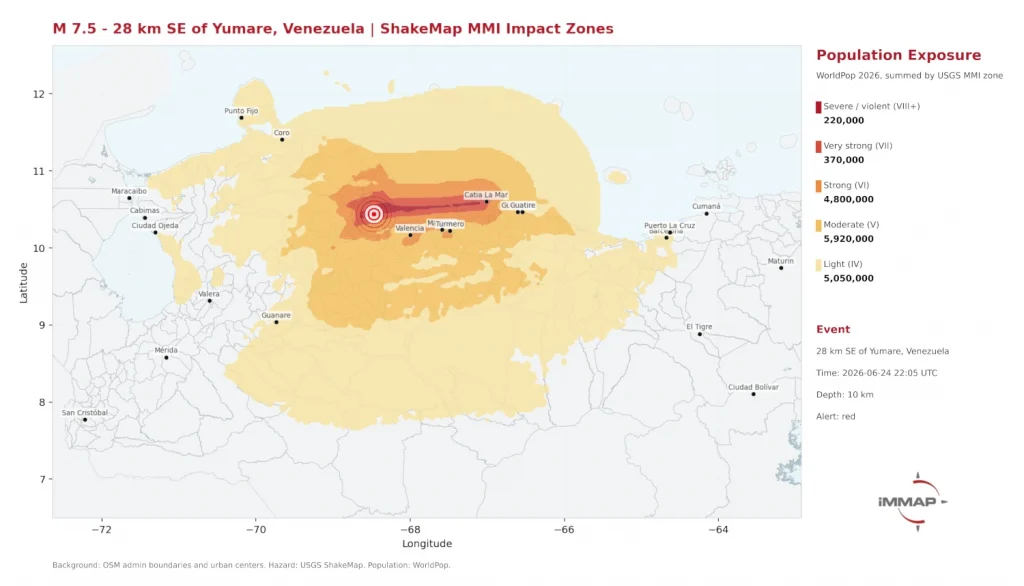
Population Data

Map showing aggregated incidence of COVID-19 confirmed infection from community transmission from June 2020 to June 2021, Dakar, Senegal

New Disease Mapping Identifies COVID-19 Hotspots in Dakar to Guide Public Health Interventions

Take Our Survey and Help Shape What Comes Next A new study by an international team of researchers has successfully mapped the neighbourhood-level spread of COVID-19 in Dakar, Senegal, revealing that high-density residential areas in the city’s west face the greatest risk of infection. The research, led by WorldPop Research Fellow, Dr Assane Gadiaga at the University of Southampton […]

New Disease Mapping Identifies COVID-19 Hotspots in Dakar to Guide Public Health Interventions Read More »

Dr Edson Utazi presenting at GEOMED 2026

WorldPop Showcases Data-Driven Solutions to Global Health Challenges at GEOMED 2026

Take Our Survey and Help Shape What Comes Next Last week, WorldPop researchers demonstrated how advanced geospatial mapping and machine learning can solve critical global health challenges, from tracking viral tourism trends to reaching “zero-dose” children. Presenting at the GEOMED 2026 conference at the Public University of Navarre, Pamplona, Spain, Dr Edson Utazi, Krishnaveni KS

WorldPop Showcases Data-Driven Solutions to Global Health Challenges at GEOMED 2026 Read More »

Photo of Dr Sarchil Qader, Tuli Amutenya and Ian Coady at the 2026 Global Data Festival in Nairobi.

WorldPop Experts Pioneer the Future of Population Intelligence at 2026 Global Data Festival

Take Our Survey and Help Shape What Comes Next During the 2026 Global Data Festival in Nairobi, WorldPop researchers showcased how high-resolution geospatial mapping and artificial intelligence are transforming the way nations count and improve outcomes for their citizens. The event, which was held jointly with the Kenya Space Expo & Conference, brought together international

WorldPop Experts Pioneer the Future of Population Intelligence at 2026 Global Data Festival Read More »

Screen capture of graphic from ArcGIS Scene Viewer of Global Projected Count of Children Under Age 5 for 2030 derived from 1-km cell size WorldPop Global2.

WorldPop Global 2 Demographic Data Now in ArcGIS Living Atlas 

Take Our Survey and Help Shape What Comes Next Access to high-quality demographic data is often one of the biggest barriers to evidence-based decision-making. Whether supporting health service planning, humanitarian response, infrastructure investment, or climate adaptation, organisations need population data that is both current and spatially detailed.  That is why we are pleased to see

WorldPop Global 2 Demographic Data Now in ArcGIS Living Atlas  Read More »

Photo of Child fetching water in northwest Somalia

WorldPop Open Data Helps UNICEF Pinpoint Children’s Climate Vulnerability

Take Our Survey and Help Shape What Comes Next UNICEF is launching the Global Child Hazard Database (GCHD) at London Climate Action Week later this month. The GCHD initiative provides globally standardised datasets on children’s exposure to overlapping climate and environmental risks. The project aims to provide timely and accurate data to support informed decision-making and policy advocacy for the world’s youth.  Central to this

WorldPop Open Data Helps UNICEF Pinpoint Children’s Climate Vulnerability Read More »

Graphic showing geographic distribution of median area sizes of subnational units in the input population data for the Global Subnational Demographic Dataset 2010–2030

Mapping a World in Transition: New Study Lays Foundation for WorldPop Global 2 Population Data 

Take Our Survey and Help Shape What Comes Next WorldPop researchers at the University of Southampton have published the methodology behind the massive subnational dataset used to power Global 2 – our latest high-resolution mapping of the human population.  The new article, published as a preprint in VeriXiv, details how the team harmonised and projected population data for more than 716,000 subnational administrative units across

Mapping a World in Transition: New Study Lays Foundation for WorldPop Global 2 Population Data  Read More »

Screen capture of Lagos, Nigeria population pyramid.

Open-access WorldPop data reveals hidden demographic trends across 10,000 cities

Take Our Survey and Help Shape What Comes Next High-resolution data from WorldPop is uncovering critical demographic shifts in over 10,000 cities that national averages often hide. The study, led by Dr Andrew Zimmer and published in Nature Cities, provides a globally consistent view of urban change between 2000 and 2020.  Researchers used WorldPop’s anonymised and aggregated gridded population distributions to track age and sex

Open-access WorldPop data reveals hidden demographic trends across 10,000 cities Read More »

Photo of Dr Chris Nnanatu presenting at the High Level Engagement meeting.

Mapping Nigeria’s Future: The Road to a Smart National Census

Take Our Survey and Help Shape What Comes Next An important leap toward a modern and credible national census took place recently in Abuja, Nigeria. On April 30, 2026, the Federal Government officially launched an 18-month initiative to consolidate and modernise Nigeria’s national geospatial database. This high-level event brought together key leaders from the National

Mapping Nigeria’s Future: The Road to a Smart National Census Read More »

DHIS2 webinar screen capture

New webinar showcases how geospatial data reaches zero-dose children in remote regions

Take Our Survey and Help Shape What Comes Next Last week, the DHIS2 community broadcast a significant webinar detailing how high-resolution WorldPop population data has been integrated into the DHIS2 platform. This digital integration is transforming how life-saving vaccines are delivered in low- and middle-income countries. With WorldPop’s 100m population grid cells now integrated in

New webinar showcases how geospatial data reaches zero-dose children in remote regions Read More »

Photo of health clinic for Congo refugees in Uganda

Refugee-hosting districts show stronger maternal health outcomes in Uganda, study finds

Take Our Survey and Help Shape What Comes Next Districts in Uganda that host refugees are seeing slightly better maternal and child health outcomes than those that do not, according to new research analysing routine health data from 2020 to 2023.  The Countdown to 2030 study, led by Rogers Nsubuga, PhD researcher at Makerere University, Uganda, found higher coverage in

Refugee-hosting districts show stronger maternal health outcomes in Uganda, study finds Read More »