
When two powerful earthquakes struck near Yumare, Venezuela, on 24 June, humanitarian responders needed to understand quickly how many people had been affected and where support would be needed most. Open population data from WorldPop helped provide those critical early insights.
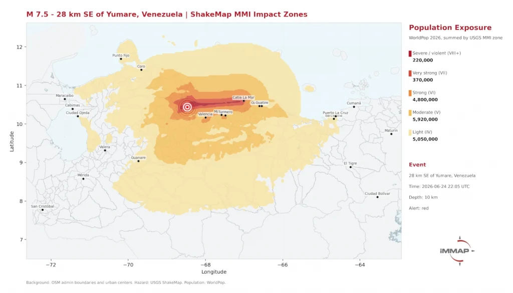
The earthquakes, measuring magnitude 7.2 and 7.5 just one minute apart, triggered red alerts from the US Geological Survey. iMMAP, an international non-profit organisation that provides information management and geospatial analysis to support humanitarian response, combined USGS ShakeMap intensity data with WorldPop’s 2026 high-resolution population estimates to rapidly assess potential impacts.
The analysis estimated that around 590,000 people were exposed to severe to violent shaking (Modified Mercalli Intensity VII or higher), while 4.8 million experienced strong shaking (MMI VI) from the larger earthquake. In total, more than 16 million people were located within the earthquakes’ overall impact footprint.
By combining earthquake hazard information with detailed population maps, responders can identify where affected communities are likely to be, estimate the scale of humanitarian need and prioritise search and rescue, relief supplies and recovery efforts. This provides a far more detailed picture than population statistics reported only for large administrative areas.
The analysis also showed that the stronger earthquake extended towards the densely populated Valencia–Caracas corridor, while the close succession of the two events increased the likelihood of cumulative damage, disrupted access routes and overlapping humanitarian needs.
The response in Venezuela demonstrates how freely available, high-resolution population data can support faster, evidence-based humanitarian decision-making. By making these datasets openly accessible, WorldPop helps governments and humanitarian organisations direct resources where they are likely to have the greatest impact when every hour counts.
Image: Screen capture of shake impact zones, ReliefWeb, 2026
Learn more
- Shake Impact Zones (ReliefWeb)
- WorldPop data covering Venezuela earthquake (Humanitarian Data Exchange – HDX)
- WorldPop Open Data
- WorldPop Free Learning Resources