Open Buildings data

Regional map of West and Central Africa showing results from the Reach the Unreached project

Despite Progress Nearly 1 Million Children in West Africa Still Miss Out on Life-Saving Vaccines 

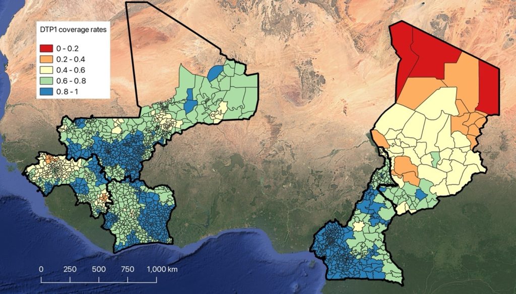
By Attila N Lazar and Tim O’Riordan While global immunisation efforts have seen significant progress, our new high-resolution, digital population and vaccination coverage maps produced for the UNICEF-funded Reach the Unreached project indicate that nearly one million children in five West and Central African countries remain unreached by vaccination services. Despite increased access in many […]

Despite Progress Nearly 1 Million Children in West Africa Still Miss Out on Life-Saving Vaccines  Read More »

Screen capture form Google Earth of Nairobi, Kenya

The We Society: Population, Data & Destiny

In a fascinating conversation with journalist and Academy of Social Sciences President Will Hutton, Professor Andy Tatem explains how satellite imagery and mobile phone data are transforming population mapping across the Global South. Used by governments for critical resource allocation, these data is reshaping how policies are made. Professor Tatem shares real-world examples from Papua

The We Society: Population, Data & Destiny Read More »