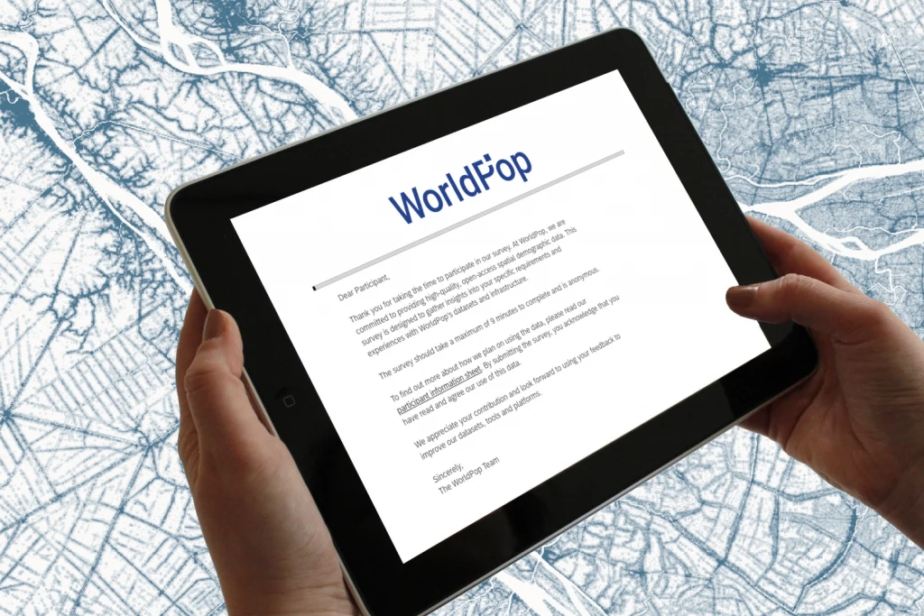
Global 2

AI generated image showing public health analysts, humanitarian responders, researchers, and urban planners using tablets, maps, and data dashboards, illustrating real-world impact. Caption reads "1,000,000+ open data downloads since 2019"

Celebrating a Milestone: 1 Million Downloads and Counting

We’re thrilled to celebrate a major milestone in our mission to ensure that everyone, everywhere is counted in decision-making. Since 2019, our open spatial demographic datasets have reached over 1 million downloads from our own site – adding to the hundreds of thousands more from our data hosting partners including HDX, ESRI’s Living Atlas, and

Celebrating a Milestone: 1 Million Downloads and Counting Read More »

Animation showing level 2 degree of urbanisation around Kinshasa, 2015-30

Mapping People, Places and Change: Exploring WorldPop’s Latest Global Data Releases

Understanding where and how populations are distributed, and how they shift over time, is at the heart of planning for health services, responding to disasters, designing cities, and tackling global challenges like climate change. WorldPop’s mission has always been to make high-resolution population and demographic data openly available, and the latest batch of global datasets

Mapping People, Places and Change: Exploring WorldPop’s Latest Global Data Releases Read More »

Photo of a truck a, a bus and a motorcycle on a city street during a flood.

The Data Behind the Shield: How Early Warnings and Population Maps Save Lives

Each year, tropical cyclones threaten more than a billion people living in low-lying coastal cities. As storms grow more intense and cities expand, the stakes are rising. But a recent study led by Dr Haiyan Liu, a visiting researcher with WorldPop, shows that multi-hazard early warnings supported by more effective use of data can dramatically

The Data Behind the Shield: How Early Warnings and Population Maps Save Lives Read More »

Photo of Suri Woman carrying a child while walking on a dirt road, Tulgit

Mapping the Last Mile: How Data Is Helping Reach Unvaccinated Children

Imagine a life-saving vaccine is available, but reaching it means walking for hours, sometimes days. For millions of families in low- and middle-income countries, this isn’t a thought experiment. It’s everyday life. In 2021 alone, around 15.7 million children did not receive their first dose of the diphtheria-tetanus-pertussis (DTP1) vaccine. One of the biggest challenges

Mapping the Last Mile: How Data Is Helping Reach Unvaccinated Children Read More »

Photo of Street Vendors, Guilin, China

When Heatwaves Strike, Do City Adaptation Measures Really Help?

As climate change intensifies, extreme heat is becoming a daily reality for millions of people living in cities. In response, governments are rolling out heat adaptation measures such as cooling centres, greener urban spaces and public heat warnings. But a crucial question remains: do these strategies actually work, and do they work equally for everyone?

When Heatwaves Strike, Do City Adaptation Measures Really Help? Read More »

Photo of delegates at the Human Planet Forum, JRC Ispra, Italy - 19–21 November 2025

Progress in Population and Urban Data: Highlights from the Human Planet Forum 2025

The 2025 Human Planet Forum gathered global experts in population modelling, urban analytics, and Earth observation for three days of scientific progress and growing collaboration. A central theme throughout the meeting was the acceleration of high-resolution, openly accessible global datasets and included a presentation by Professor Andy Tatem of our new, open Global 2 (2015-2030)

Progress in Population and Urban Data: Highlights from the Human Planet Forum 2025 Read More »

Animated GIF of Khartoum

WorldPop Global 2: A New Era of High-Resolution Population Data

This week, WorldPop Director Professor Andy Tatem presented during the Monitoring, projecting and hindcasting of human settlements, infrastructure and population session at the Human Planet Forum 2025, introducing the next generation of WorldPop’s global population datasets: Global 2 (2015–2030). These new datasets represent a major step forward in how the world measures, understands, and anticipates

WorldPop Global 2: A New Era of High-Resolution Population Data Read More »

Screen capture from webinar

Mapping People, Powering Response: WorldPop’s Work in Focus

Last month, Principal Enterprise Fellow, Dr Natalia Tejedor Garavito showcased WorldPop’s innovative work at CrisisReady’s Café Catastrófico webinar series. Dr Tejedor Garavito spoke on how WorldPop helps countries, especially those with limited resources, to answer a critical question: where are people, and how many are there? Using satellite imagery, mobile data, and advanced statistical models,

Mapping People, Powering Response: WorldPop’s Work in Focus Read More »

Screen capture of The Power of Population Data webinar, showing Dr Maksym Bondarenko, Dr Jessica Espey and Professor Andy Tatem

New Global Population Dataset Unveiled at Packed WorldPop Webinar

Over 350 people from across the globe tuned in this week to our live webinar as we launched our most advanced population dataset yet – Global 2. Held on 4 September and hosted by Deputy Director, Dr Jessica Espey, The Power of Population Data event showcased how forward-looking data science is transforming our understanding of

New Global Population Dataset Unveiled at Packed WorldPop Webinar Read More »