

The 2025 Human Planet Forum gathered global experts in population modelling, urban analytics, and Earth observation for three days of scientific progress and growing collaboration. A central theme throughout the meeting was the acceleration of high-resolution, openly accessible global datasets and included a presentation by Professor Andy Tatem of our new, open Global 2 (2015-2030) datasets – described as a major step forward in the availability, quality, and usability of fine-scale population data.
The newly released WorldPop Global 2 dataset provides annual, sex- and age-disaggregated population estimates from 2015–2030 on a 100 m grid for 242 countries. The dataset integrates population data from the 2010 and 2020 census rounds, improved building footprint and settlement layers, demographic projections, built settlements growth models, and a suite of additional geospatial covariates. Professor Tatem outlined follow-on developments to Global 2 that will expand and deepen the dataset’s value:
- Population densities and administrative summaries to support more granular planning.
- Degree of Urbanisation classifications, aligning with UN statistical frameworks.
- Integration of census-independent bottom-up estimates co-developed with national statistics offices, ministries of health and UN partners.
- Support for integrated assessment and climate modelling communities, including global future SSP scenario datasets, disaggregated by age/sex and with uncertainty metrics.
Urban analytics featured prominently at the event. Professor Lewis Dijkstra, lead on territorial and city analysis at the European Commission Joint Research Centre (JRC), presented the Global Human Settlement Layer (GHSL). GSHL uses satellite imagery, census data and volunteer geographic information to produce detailed maps of where buildings and infrastructure exist. The suite of data helps researchers, planners and policymakers understand human settlement, urbanisation, disaster exposure, environmental impact and access to resources across the globe.
A new global urban neighbourhood segments layer – City Segments Layer v1 – was presented by Dr Dana Thomson and Dr Greg Yetman (CIESIN). This is an open vector-based breakdown of all cities worldwide that divides urban areas into neighbourhood-sized units, based on building density, roads, and water features. The aim is to help identify local socioeconomic conditions and urban vulnerabilities.
The UN Food and Agriculture Organization, working with the University of Twente, showcased new global accessibility analyses and a multi-tier city regions (MTCR) framework, available online through the interactive FAO City Regions Explorer. This new application uses interactive maps and advanced data analytics to visualise how urban and rural areas are connected. This enables smarter regional planning and stronger urban–rural linkages for sustainable agrifood systems.
Informal settlement mapping emerged as one of the most dynamic fields, with numerous teams developing satellite-derived datasets. Forum participants called for stronger coordination, shared validation standards, and joint method development, moving from fragmented research toward collective progress.
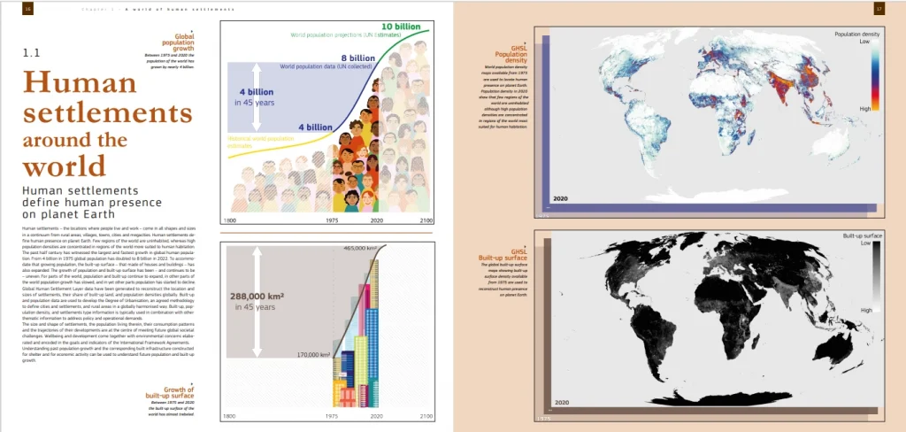
Delegates were presented with hard copies of the JRC’s The Atlas of the Human Planet 2024. This document (which is also available as a pdf online) highlights how scientists use free and open data from the EU’s Copernicus programme to reveal how human settlements interact with the environment. Through maps, graphics, and analysis, it shows how population growth and urbanisation affect ecosystems, climate, and sustainable development, providing data and insights to help governments and organisations plan for a more resilient and sustainable future.
From the JRC, Sara Gonzalez presented new comparative analyses of four major open, non-government building-footprint datasets used across the European Union: OpenStreetMap, EUBUCCO, the Digital Building Stock Model, and Microsoft’s AI-generated building footprints. The study found that all datasets tend to be more complete in cities and less complete in rural areas.
With its strong focus on open data, shared methods, and collective validation, this year’s Forum underscored a maturing global community dedicated to understanding the human presence on Earth.
Learn more
- Explore WorldPop open data
- WorldPop Global 2: A New Era of High-Resolution Population Data (WorldPop)
- WorldPop ‘Global2’: Global high-resolution population estimates for 2015-2030 (WorldPop)
- Global Human Settlement Layer (JRC)
- Atlas of the Human Planet 2024
- City Segments Layer v1 (CIESIN)
- City regions explorer (FAO)
- Pan-European open building footprints: analysis and comparison in selected countries (The International Archives of the Photogrammetry, Remote Sensing and Spatial Information Sciences)
- Group on Earth Observations
- Human Planet Forum 2025