
A significant development in population data mapping led by WorldPop Research Fellow Dr Wenbin Zhang promises to improve everything from disaster response to urban planning by offering clearer, more accurate figures.
Governments and aid organizations around the world rely on gridded population datasets to make crucial decisions – like where to build hospitals, send vaccines, or prepare for natural disasters. These maps break down populations into small spatial units, offering a flexible alternative to traditional census data tied to administrative boundaries. But there’s been a long-standing hitch: the numbers often come in fractions (like 2.3 or 0.8 people in a grid cell) making them hard to apply in the real world.
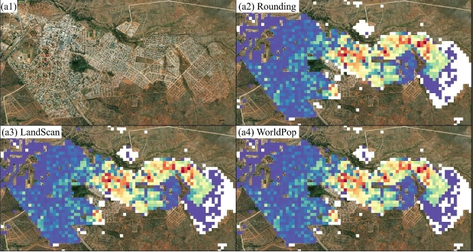
Simple rounding may seem like an obvious fix, but it causes problems. It can distort total population counts, erase signs of sparsely populated areas, and create “peanut butter smears” – unrealistically smooth population spreads that don’t reflect real settlement patterns. Alternative methods, like the one used by LandScan, adjust for totals but fall short when it comes to keeping detailed demographic data – like age or sex – consistent.
Now, our researchers have developed a new solution: the WorldPop integerisation method. This innovative approach breaks down each fractional population estimate into whole numbers, then uses probability to fairly distribute the leftover fractions. The result? Whole-number population counts that still add up to accurate totals and maintain demographic detail, right down to each grid cell.
Key advantages of the method include:
- Accuracy and consistency: It ensures that overall and subgroup populations (like children under five or elderly adults) stay in sync.
- Improved readability: Whole numbers are easier to interpret, especially in rural or low-density regions.
- More realistic maps: Unlike older methods, this one preserves peaks and valleys in population
- Broader applications: The method isn’t just for mapping people – it can help allocate vaccines, estimate disease burden, or model synthetic populations where exact counts matter.
A journal article led by Dr Zhang has been published and the team have made the method publicly available through an open-source R package called IntPopGrids, making it easy for researchers and planners to adopt.
With this advancement, planners and policymakers can now work with clearer, more actionable data that offers a new level of precision for decisions that affect lives and livelihoods.
We’re trialling the ‘Deep Dive’ audio summary feature of Google’s NotebookLM. This feature uses AI to create a podcast-like audio conversation between two AI-derived hosts that summarise key points of a document - in this case the Stochastic Approach to Integerize Floating-point Estimates article in International Journal of Geographical Information Science.
As Google acknowledge that NotebookLM outputs may contain errors, we have been careful to check, edit and validate this audio.
Please contact us to let us know what you think.
Music: My Guitar, Lowtone Music, Free Music Archive (CC BY-NC-ND)
Learn more
A stochastic approach to integerise floating-point estimates in gridded population mapping (International Journal of Geographical Information Science)
IntPopGrids (Github)