
Reliable population data is one of the foundations of effective decision-making. Governments use it to plan schools, hospitals and infrastructure. Humanitarian agencies rely on it to deliver aid. Health organisations need it to estimate how many vaccines, medicines and health workers are required in different communities. Yet for many countries, obtaining accurate and up-to-date population data remains a major challenge.
A new review led by Professor Andy Tatem explores how advances in satellite imagery, geospatial data and statistical modelling are helping address these gaps. Published in Proceedings of the National Academy of Sciences (PNAS), the study examines the rapid development of “bottom-up” population estimation methods that can produce detailed population maps even when census data are outdated, incomplete or unavailable.
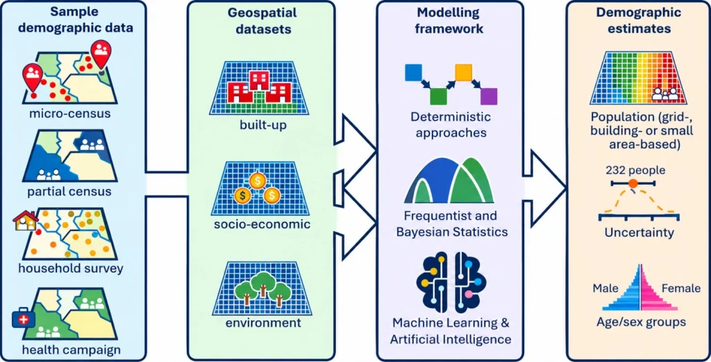
Unlike traditional approaches that rely heavily on national censuses, bottom-up methods combine small-scale surveys, household listings and community-level data with information collected from satellites and other geospatial sources. These datasets are used to estimate population numbers across areas where no direct data exist, creating detailed maps of where people live and how populations are changing.
One of the biggest advances highlighted by the researchers is the growing availability of high-resolution maps of buildings and settlements derived from satellite imagery. Modern datasets can now identify individual building footprints across large parts of the world, providing valuable clues about where people are likely to live. These data can then be combined with demographic information and analysed using sophisticated statistical and machine-learning methods to generate highly detailed population estimates.
The impact extends far beyond academic research. The paper describes how these population estimates are already supporting vaccination programmes, disaster response operations, education planning and efforts to measure progress towards the Sustainable Development Goals. By providing population data at scales as small as 100 metres, decision-makers can better understand the needs of local communities and target resources more effectively.
Importantly, the models do more than estimate where people live. They also measure uncertainty, helping users understand where estimates are reliable and where additional data collection may be needed. This can be particularly valuable in health planning and humanitarian response, where knowing the possible range of a population estimate can improve preparation and resource allocation.
Despite major progress, challenges remain. Some communities are difficult to count because of conflict, displacement, dense vegetation, rapid urban growth or limited access for survey teams. The researchers also stress the need to address potential biases in new digital data sources, such as anonymised mobile phone records, and ensure that population estimates are used responsibly and ethically.
The review concludes that the technology and methods behind census-independent population estimation have matured significantly over the past decade. Increasingly, the main challenges are not technical but institutional: building local expertise, strengthening national statistical systems and ensuring countries can confidently use, maintain and own these approaches themselves.
Several countries, including Burkina Faso, Mali, Papua New Guinea, South Sudan and Colombia, have already applied these methods to support planning and census activities. As population data gaps continue to grow in many parts of the world, the researchers believe these approaches will play an increasingly important role in ensuring that communities are visible in the data used to shape public policy, development programmes and humanitarian action.
Headline image: Components of the bottom–up approach to small area population estimation.
Learn more
- Advances in small area population estimation in the absence of national census data (Proceedings of the National Academy of Sciences)
- WorldPop Open Data
- WorldPop Free Learning Resources