
An international team of researchers, including experts from the WorldPop group at the University of Southampton, has challenged recent claims that gridded global population maps systematically undercount rural communities. In a comprehensive response to a study published in Nature Communications, the team argues that allegations of a 50% undercount are based on a flawed research design that misinterprets local data anomalies.
The Flaw in the “50% Underrepresentation” Claim
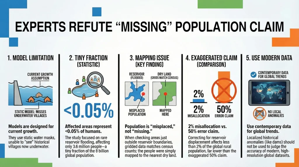
The dispute centres on how high-resolution geospatial mapping captures populations in areas affected by dam and reservoir construction. Previous research claimed that gridded datasets fail to represent people in these regions; however, the WorldPop team and their partners demonstrate that these findings are based on “misleading” relative error metrics.
While the original study focused on 35 countries where rural areas were flooded, this specific sample represents less than 0.05% of the world’s population. The researchers point out that using local anomalies to judge the quality of global datasets is an “exception fallacy” that does not reflect the accurate and contemporary distribution of rural populations worldwide.
Technical Constraints vs. Systemic Flaws
The researchers explain that the observed discrepancies are expected limitations of population disaggregation models rather than fundamental flaws. Most global models currently rely on:
- Static Water Masks: Models often assume water bodies remain unchanged over time and do not automatically reflect new reservoirs.
- Growth-Only Building Stock: Current datasets typically track the growth of building footprints but struggle to measure settlements that have been dismantled, destroyed, or flooded.
“Gridded global population models are designed to redistribute census-based counts into 100m or 1km sq. grid cells,” says Professor Andy Tatem, Director of WorldPop at the University of Southampton. Prof Tatem comments: “These models assume stationarity in water bodies and are not intended to capture rare, local events like the flooding of individual villages by new dams. This is a documented limitation, not a systemic bias”.
Misallocation vs. Missing Data
A core issue highlighted in the response is the confusion between “missing data” and “misplaced data”. The researchers found that while people might not be placed within the exact boundaries of a new reservoir, they are still represented in the aggregated data in nearby grid cells.
When the analysis is extended just five kilometres beyond reservoir boundaries, the differences between datasets largely disappear. The team estimates that reservoir-related displacement affects only 1.2% to 1.9% of the global rural population, a far cry from the 50% claimed.
Ensuring Data Accuracy for Global Decision Making and Development
The availability of timely and accurate geospatial data remains critical for achieving global goals. Despite rare local inaccuracies, gridded population datasets provide an essential tool for vaccination campaigns, disaster relief, and poverty reduction. The team emphasizes that source data quality and mapping capabilities have improved significantly over time, ensuring contemporary rural estimates remain a robust foundation for decision-making.
We’re trialling the ‘Deep Dive’ audio summary feature of Google’s NotebookLM. This feature uses AI to create a podcast-like audio conversation between two AI-derived hosts that summarise key points of documents - in this case the full preprint article linked below.
As Google acknowledge that NotebookLM outputs may contain errors, we have been careful to check, edit and validate this audio.
Please contact us to let us know what you think.
Music: My Guitar, Lowtone Music, Free Music Archive (CC BY-NC-ND)
Learn more
Study Citation: This response is detailed in the preprint: “Reply to: Global gridded population datasets systematically underrepresent rural population,” by Uhl et al. (2026).
Funding Credits: Contributors to this work include the Joint Research Centre (JRC) of the European Commission, WorldPop, and the Center for International Earth Science Information Network (CIESIN) at Columbia University.