Collaborators/funders: Bill and Melinda Gates Foundation, UNFPA, Oak Ridge National Laboratories
High resolution spatially disaggregated population data is needed to support the planning of service provision, or for response activities in emergency situations. In many cases, national census data can be used to provide such spatially disaggregated demographic information (‘top-down’ population mapping). However, censuses are normally conducted every ten years and so data is often out of date. In addition, the most recent census to have been conducted in some low income countries is already 20 or more years out of date. Where up-to-date or unreliable census data is not available, an alternative method is needed to estimate population densities across a country.
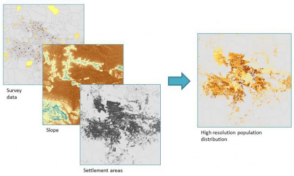
‘Bottom-up’ population mapping methods are being developed to estimate subnational population distributions in the absence of census data, using survey data in combination with satellite and other ancillary data sources. Survey data, where the number of people has been recorded for specific discrete areas across a country (in contrast to census data, which aims to record the complete population across a country), are the primary input for ‘bottom-up’ population mapping. These types of surveys are faster and less costly than conducting a full national census and the results can be extrapolated to estimate populations even in un-surveyed locations. Survey data are linked based on spatial location, to a range of ancillary data sources, which can provide information relevant to the distribution of human populations. Ancillary data which may be used for this purpose includes topographic information (elevation, slope); transport networks; climatic variables and, importantly, the location and type of human settlements (e.g. residential versus commercial). Statistical regression is used to quantify the relationships between population density (from survey data) and ancillary datasets, and these relationships can then be used to predict population density across a high-resolution spatial grid, including in un-surveyed locations.
Fig. 1. Spatial regression of survey data with ancillary data layers allows estimation of high resolution population surfaces, including in un-surveyed locations.