When disasters such as floods, earthquakes or hurricanes strike, there is a need for rapid assessments of numbers of people likely to be exposed to estimate the scale of relief required, direct resource allocation and plan field operations. Advances in satellite-based mapping of floods, hurricane track forecasting and earthquake measurement have facilitated improved precision in delineating areas affected. However, available population data has typically been restricted to totals for provinces or districts, limiting the accuracy with which estimates of populations exposed can be calculated.
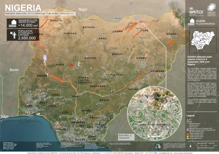
UNOSAT-UNITAR map of flooding in Nigeria in September 2024, including estimates of population exposed using WorldPop data. Source: unosat.org
To address this, WorldPop has partnered with organizations such as UN-OCHA, UNOSAT, the World Food Programme (WFP), UNICEF, ACLED and MapAction, to ensure that relevant and timely small area estimates of population totals and their age/sex breakdowns are openly available. This has driven widespread usage of WorldPop datasets in disaster response, including (i) the routine use of WorldPop population data by UNOSAT-UNITAR in their analyses and mapping, (ii) the integration of WorldPop data into WFP’s Advanced Disaster Analysis and Mapping (ADAM) operational system, (iii) development of a conflict exposure tool and routine set of metrics by ACLED, and (iv) regular publication of visualisations based on WorldPop data in major news outlets such as the New York Times, Reuters, BBC and Washington Post.