
A Demographic Data Basis for the United Nations
UN agencies are responsible for the production of a wide range of international indicators, metrics and statistics that support advocacy, strategy design and the measurement of progress towards development goals. Underpinning many of these is the need for globally comparable and consistent data on the target populations. As the ability to measure and map key indicators like disease prevalence, access to services and the extents of disasters at small area scales has improved, the need has risen for similar scale population data to provide denominators and populations at risk measures. Through the production of open, globally-consistent, age/sex-structured and multi-temporal high resolution population datasets, WorldPop has been able to meet this need, resulting in widespread usage of its datasets by UN agencies. A selection of examples are outlined below.
The World Health Organization produces the World Malaria Report each year, which is the basis for global advocacy, fundraising and strategy. In countries where surveillance systems and reporting of case numbers are weak, geospatial modelling methods are used to estimate prevalence from surveys. These are then combined with WorldPop’s age-disaggregated population datasets to produce estimates of numbers of malaria cases.
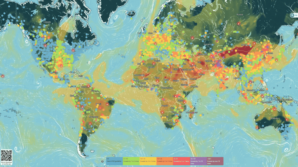
Air pollution is a growing health issue in many areas of the World, and levels fluctuate constantly across space and time. The combination of satellite and ground-based monitoring is enabling daily mapping of the presence and prevalence of many pollutants. The UN Environment Program (UNEP) has constructed an online tool to present and analyse these data, and utilised WorldPop’s global population datasets to then quantify the numbers of people exposed to pollutants at small area scales.
Despite decades of progress, 251 million children and young people are still out of school worldwide. There are many reasons behind this, but an important one is the ability to travel to a school nearby. UNESCO’s International Institute for Educational Planning works closely with governments to use digital mapping of schools and transport networks to assess where access is poor. Through integrating these analyses with WorldPop’s small area datasets on school-age children, they are able to extend these analyses to estimate numbers out-of-school and where resources should be targeted.
The UN’s Food and Agriculture Organization (FAO) is supporting countries around the World to utilise geospatial data for more targeted agriculture interventions. A central component of this is their Hand-in-Hand initiative to help target the poorest, build partnerships and design context-specific interventions. The Hand-in-Hand geospatial portal is central to these efforts, and WorldPop’s global population datasets provide its demographic basis.
While most high income countries have sufficient sexual, reproductive, maternal, newborn and adolescent health (SRMNAH) workforce, there is estimated to be major shortages across the rest of the World, including needs for almost a million midwives. To be able to target limited resources towards improving maternal mortality, neonatal mortality and stillbirth rates, subnational data on the regions with greatest need are required. WorldPop has partnered with the UN’s Population Fund (UNFPA) for many years to improve small area population data, particularly around SRMNAH, and its data form part of UNFPA’s Population Data Platform and recent State of the World’s Midwifery reports.
Further information
- World Malaria Report 2024 (WHO)
- Real-time Air Pollution Exposure Platform (UNEP IQAir)
- Hand-in-Hand Geospatial Platform (FAO)
- Population Data Portal (UNFPA)