An equitable and efficient allocation of international aid relies on knowing where funds are needed most. For instance, an efficient alleviation of poverty and measurement of the impact of distributed aid required knowing where the poor are located. Unfortunately, detailed, reliable and timely information on the spatial distribution and characteristics of intended aid recipients in many low-income countries are rarely available.
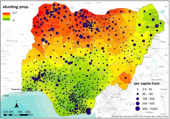
Our approach is to take advantage of the fact that indices of population health are often correlated to environmental or sociological factors, many of which are available as gridded surfaces. We use geostatistical models (machine learning and Bayesian geostatistical techniques) to produce detailed maps of these indices, together with estimates of mapping uncertainty. By combining these maps with information on the disbursement of aid, we quantify both the distribution of aid relative to population characteristics related to need, and how aid disbursement interacts with change in these indices (e.g. Figure 1).
We have been developing these approaches using three case-study countries (Nigeria, Malawi and Nepal). The output of the ongoing project will consist in high-resolution maps of poverty and stunting in children in Nigeria, Kenya and Malawi, together with related mapping uncertainty, quantifying changes in need over time and the interactions with aid disbursement .
Figure 1. Per-capita funding for nutrition overlaid on estimated proportion of children who are stunted in 2013.