Maternal and newborn health

A primary focus of WorldPop is ensuring that the methods developed and resulting output datasets undergo academic peer review. Therefore, to keep up with the latest methods, we recommend visiting our publications page. The methods outlined below are becoming outdated and have been superseded in some places – we are working to update these based on newly published papers.

Maternal and newborn health geography

Improved understanding of geographic variation and inequity in health status, wealth, and access to resources within countries is increasingly being recognized as central to meeting development goals. The lack of spatial datasets to aid in identifying the magnitude of inequities for women and newborns, both in outcomes and services, are now a key constraint to progress. Moreover, as international funding for health and development comes under pressure, the ability to target limited human resources and health services to underserved groups becomes crucial. Despite some progress in very recent years, insufficient global attention has been paid to disaggregating national data by geographical units and the maternal and newborn health community has yet to fully capitalize on the emerging capacity of GIS. In collaboration with UNFPANORADIntegrare, the World Health Organization and the Open Health Initiative of the East African Community, WorldPop is working to improve the spatial evidence base for maternal and newborn health.

Mapping the distributions of women of childbearing age

Planning for safer births and healthier newborns can be improved firstly by providing more accurate estimations of population distributions – targeting particularly women of childbearing age. WorldPop has developed methods for the high spatial resolution mapping the distributions of women of childbearing age (see example below), and details are provided here. Output age and sex-structured population distribution datasets are available to download through the data link above.

Tanzania census data showing proportions of the population who are women of childbearing age (15-49 yrs old) for each enumeration area
the census data are integrated with WorldPop’s Tanzania population distribution maps to produce estimates of numbers of women of childbearing age per 100x100m grid cell

Mapping the distributions of pregnancies and births

Spatially disaggregated projections of the approximate numbers of pregnancies and births that are likely to occur in the short and long-term are needed for more effective strategies on human resources and infrastructure. WorldPop has developed and applied methods for the high resolution mapping of pregnancies and births, across 75 of the highest burden countries in terms of maternal and newborn health. The integration of census, survey, satellite and GIS datasets is undertaken to account for the spatial and temporal heterogeneities in population distributions, age structures and fertility rates (see figure below).

Fertility rates for women aged 20-24
Fertility rates for women aged 30-34;
Fertility rates for women aged 40-44
Map showing estimated total number of live births per 100x100m grid cell

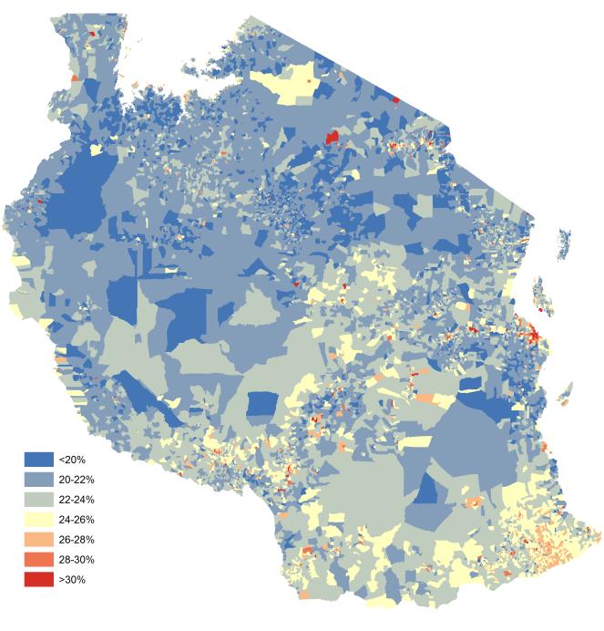
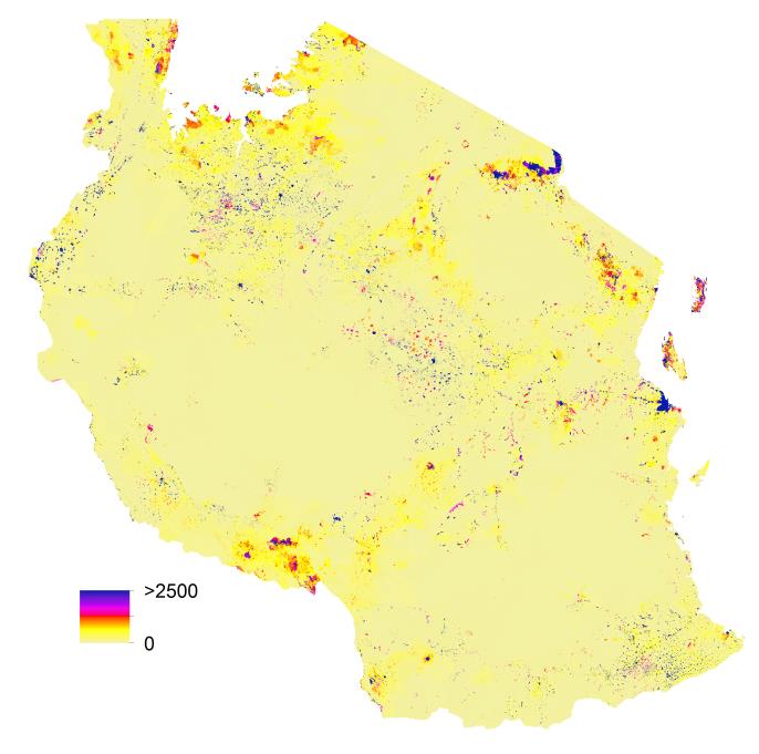
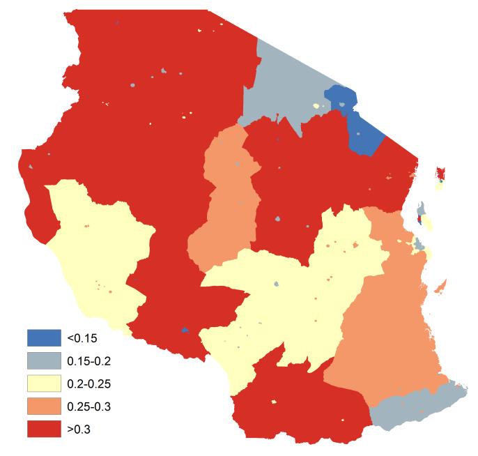
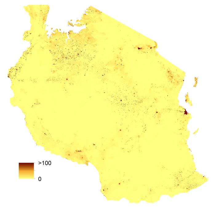
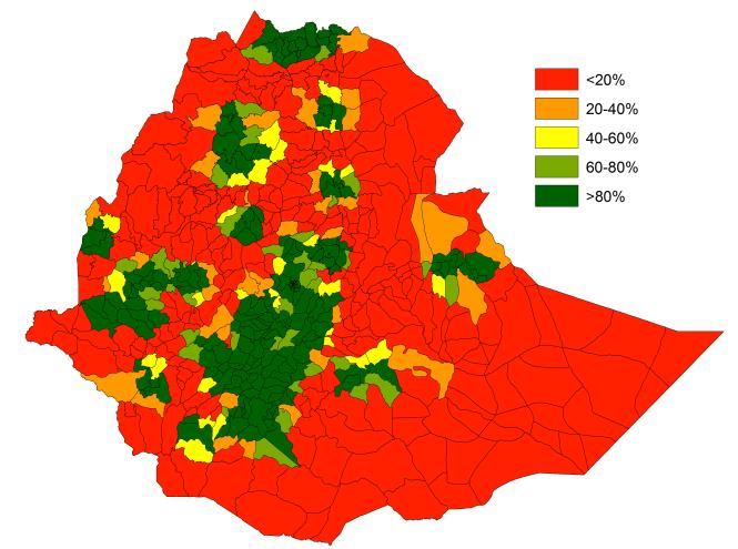
WorldPop births and pregnancies distribution datasets were used as the basis for recent analyses presented by the UNFPA, World Health Organization and the International Confederation of Midwives in the State of the World’s Midwifery 2014 report (see figure below). Ongoing WorldPop analyses are extending and updating this work.

Integrated analyses

There is a need to link information on pregnancies and births to better information on health facilities in districts and regions so that distance to services and their coverage can be assessed. WorldPop projects in collaboration with NORADIntegrare and the Open Health Initiative of the East African Community, are undertaking such analyses (example in figure below), as well as constructing new high resolution data layers on factors such as skilled birth attendance and adolescent birth rates.

estimated number of pregnancies per 100x100m grid cell in 2012 for Ethiopia, with the location of comprehensive EmONC facilities overlaid
Estimated percentage of pregnancies within 50km of a comprehensive EmONC facility in Ethiopia in 2012 by woreda administrative unit.

Atlas of Birth

WorldPop Data is also used for the Atlas of Birth Project.