Collaborators/funders: Namibia National Vector Borne Disease Control Program, Bill and Melinda Gates Foundation, Clinton Health Access Initiative
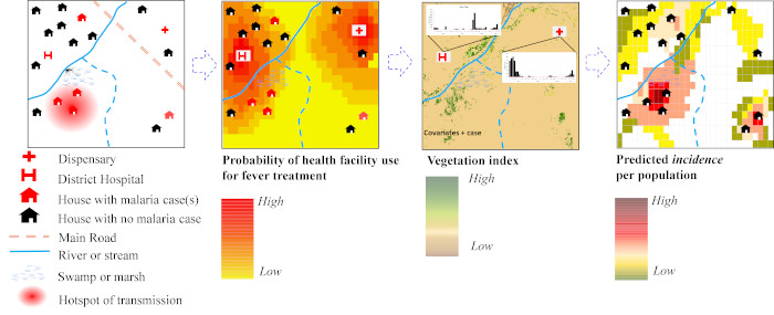
Data from health facilities provide a means of detecting hotspots of malaria transmission in countries aiming for elimination. These data have the advantage of being reported on a continuous basis at a national level providing a temporal signal that captures the seasonal variability of transmission. Malaria cases recorded at a health facility can be aggregated by month and used to produce monthly maps of malaria incidence adjusting for healthcare use, and reporting rates. Information on health facility utilisation can be obtained from geo-located nationally representative household surveys such as the Demographic and Health Surveys (DHS) or Malaria Indicator Surveys (MIS). These are used to quantify and map the probability of both public and private health facility use. It is important to adjust incidence estimates for utilisation because of variation in treatment seeking patterns. A Bayesian inference method is used to harnesses the spatial and temporal dependencies (covariance) in the observed malaria cases and their relations with environmental predictors (ecological or climatic covariates) while incorporating measures of uncertainty to produce a gridded fine spatial resolution map. This incidence map is then combined with population maps to estimate populations at risk at any level. For example, at district level, these can be used to categorize high, medium, and low transmission districts for operational and planning purposes.
Figure 1: Generalised mapping of fine scale P. falciparum incidence in low transmission settings
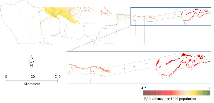
Figure 2: Example of a fine resolution monthly map of malaria incidence for northern Namibia