Collaborators/funders: Bill and Melinda Gates Foundation, World Bank, Grameen Foundation
Globally, poverty is a significant driver of the main health and welfare challenges faced by humans in the 21st century. Yet while many institutions aim to alleviate poverty using approaches ranging from donations of cash to construction of infrastructure, the challenge of equitably distributing such interventions is hampered by the difficulty of knowing exactly where poverty is greatest.
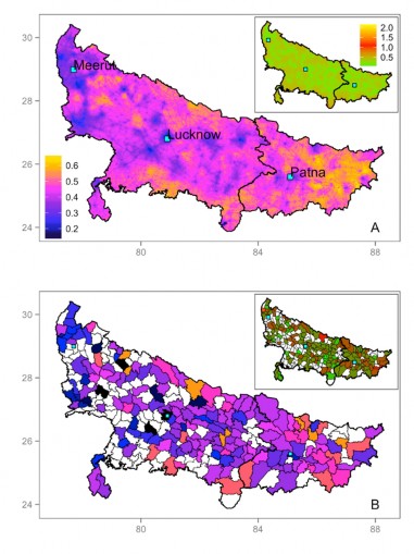
Poverty mapping can highlight inequalities within countries and provide a tool for the spatial targeting of poverty reduction policies. In this context, measures of whether individuals in a given location are likely to be above or below the poverty line are frequently used. The current standard for poverty mapping uses small area estimation which relies on census (every 10 years) and matching survey data, which can be cumbersome to collect and may simply be available. Instead, we use the Progress out of Poverty Index (PPI) – a rapid poverty assessment tool developed by the Grameen foundation – to construct high resolution maps of the likelihood of individuals living below the poverty line for Bihar and Uttar Pradesh states in India in 2014. Our approach uses geolocated survey data combined with geospatial covariate datasets in a spatial modelng framework. Using this approach we are able to predict the probability that households will be under the $1.25 threshold in areas that had no previous sampling data, highlighting the spatial heterogeneities in poverty that exist across Bihar and Uttar Pradesh. The approach provides a rapid baseline assessment that can be used to monitor change between census years and progress towards the reduction of poverty.
Fig.1. Top: predicted PPI index in Uttar Pradesh and Bihar, with uncertainty map inset. Bottom: Population numbers below the PPI poverty line and uncertainty range inset.