Collaborators/funders: Bill and Melinda Gates Foundation, Telenor, University of Washington
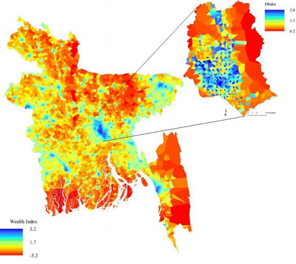
Eradicating poverty in all its forms remains a major challenge and the first target of the Sustainable Development Goals (SDGs). To eradicate poverty, it is crucial that information is available on where affected people live. These data promote informed decision making in resource allocation, poverty alleviation programs, and policies. This is especially pertinent for efforts aimed at reaching the SDGs, which need to be monitored at national and subnational levels over the coming 15 years. Spatial patterns of poverty between and within countries have been constructed using census data, but the irregular collection and unavailability of such data in many low income settings has limited the ability to produce regular updates. To complement census-based approaches, we combine data routinely collected by mobile phone operators with widely available remote sensing variables to produce accurate, high- resolution maps of multiple poverty indicators that can be readily updated. Together, indicators derived from satellite imagery and large-scale mobile operators capture distinct and complimentary correlates of human living conditions and behaviour. In Bangladesh, geostatistical models built with cell phone data, satellite-derived data, and geolocated household survey data line up well with existing small area poverty estimates, and with mapped slum areas at high resolution in Dhaka. The models explicitly incorporate the spatial relationships in the data between geographical areas, which is critically important. This creates maps with proper uncertainty metrics, and provides a means to utilize the temporal and spatial scales of non-census based datasets to regularly update poverty maps.
Fig.1. National level prediction map in Bangladesh for the mean wealth index generated using mobile phone features, remote sensing data, and Bayesian geostatistical models. Red indicates poorer areas, zoom area is the capital city, Dhaka.