Collaborators/funders: UN Foundation, Data2x program
Improved understanding of geographic variation and inequity in health status, wealth, and access to resources within countries is increasingly being recognized as central to meeting development goals. The ability to target limited resources is fundamental, especially in an international context where funding for health and development comes under pressure.
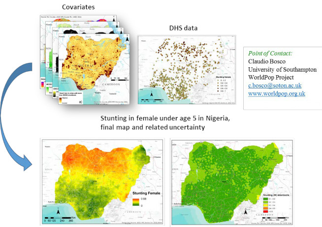
Demographic and Health surveys (DHS) data measuring the rate of stunting in children under age 5 were used to predict high spatial resolution gender disaggregated maps, at unobserved location in Nigeria, Kenya and Bangladesh, using predictive modelling techniques. Bayesian geostatistical and machine learning modelling methods (Artificial neural networks) are used to take advantage of the fact that many indicators related to population health and development are correlated to environmental or sociological factors, many of which are available nowadays as gridded spatial datasets.
The outputs consist of high-resolution maps (1×1 km) of stunting in boys and girls in Nigeria, Kenya and Bangladesh together with estimates of mapping uncertainty. Quantify the distribution of gender disaggregated childhood stunting in low- or medium-low- income countries is valuable to adequately inform policy-makers and decision-makers for promoting any initiative aimed at making advances towards reducing stunting and achieving gender equality.
Fig. 1. Visualisation of approach and outputs for mapping stunting in girls in Nigeria in 2013